


The town of Balchik is situated on tiers onto a big ancient landslide. The terrain is cut in the north-south by deep gulches on the territory of the city and in the villas zones as well. The territory is rather complicated because of the relief. Nowadays we can divide the town in two parts – the old town, situated amphitheatrically on the steep shore and the new town situated on the plateau above it. Near the new town is separated industrial and storehouse zone. The population of the town is 13 561 inhabitants.
The natural environments together with its resources specify the social economical development of the municipality Balchik. As a result two different by their economical characteristic parts of the territory are formed – an inland area (agricultural) and a seaside area. The territory of the municipality can be divided into two geographical regions:
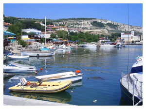
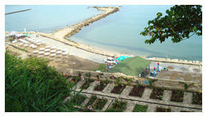
- The first region includes the Black sea coast ad the valley of the river Batova. The coastal line of the Batova river is low, with long beaches (forest reserve Baltata, Albena) In the rest the coast is steep and reaches 150 m height. The beach strip reaches up to 30 kilometers in length which is an important condition for the development of the region in the sphere of tourism and recreation.
- The second region is a part of Dobroudja plain. The Dobroudja plateau has slightly hilly relief. The height varies from the sea level to the plateau level and reaches up to 250 meters, hence the unevenness of the terrain.
The agricultural fund of the region is 42 663,4 hectares, 35 884,4 of them arable lands. The woods cover an area of 5996,4 hectares and the populated area is about 1695,5 hectares.
 This region is extremely rich in mineral springs and underground waters which are the main sources for the modem water-supply system with a capacity of 1000 liters per second. Some mineral ore deposits were found around the village of Obr?chishte. There are 67 water drills, 10 of which are mineral. Waters are also presented by the lower course of rivers Batova and Kranevska.
Within the municipality borders there are found industrial deposits of manganeseese and black mineral coals. The ore bed is between 280 - 420 meters in depth and 10 meters in lift and is more then 62 mln tons.
History
BALCHIK - 2600 years old
Balchik (formerly known as the city of Dionysos - Dionysopolis) is a small but very romantic Bulgarian seaside town located on Black Sea coast. Apart from the main stream of the tourists visiting Bulgaria and by all means unknown to the world, Balchik was preserved until today in its own multicultural authenticity. In this small town and in the region are living peacefully people whose ancestors are (in order of settling) ancient Greeks, Bulgarians, Turks, Tatars, Gypsies, Roumanians - not including individuals belonging to other minorities.
The town is 2600 years old - one respectable age. During this time it has been known as the Greek colony of Cruny, the Greek-Byzantine fortress Dionysopolis, the Medieval Bulgarian town of Karvuna, the Ottoman Turkish and later Bulgarian town Balchik up to now. The town was shortly conquered from the army of Polish King Wladislaw III Jagelo Warnenchik (1443/44) and the Ukrainian Cossacks (1604). In years 1913-1915 and 1919-1940 Balchik was under Rumanian rule - at that time the Summer Palace was built.
 CRUNY - THE LEGENDARY
Though there are very few historical sources informing about the foundation of the ancient Greek settlements along the Western Black Sea coast, it becomes evident that the first and most important centers of the ancient civilization - Istros, Tomis. Calaus, Apolonia (nowdays Sozopol), Odessos (now Varna) and Messambria (Nessebar) were set up in the period between 620 -575 BC According to Herodotus the town of Crunoy (Cruny) was established during the reign of king Astiag - an ancient ruler of present day Asia Minor. As the legends in the old chronicles say the native population together with the merchant seafarers from Yonian Greece (present day Asia Minor) organized the living in the new town named Cruny. Translated from Greek this title means water springs. It derives from the fact that the lands in the region were extremely rich in mineral springs and underground waters. Life in the town prospered through a brisk trade oversea. Close trade relations were established with all Mediterranean countries. At that stage of development the settlement was found in the mid-fourth century by Philip II of Macedon. It is still a moot question whether the title of the town was changed exactly at that time or later by those of the inhabitants who believed in Thracian Orphism. If we trust this extract from an ancient chronicle: „... during a violent storm the sea cast ashore a statue of Dionysos..." it becomes evident that the change in the name of the town was an act of paying honor to the God Dionysos. On the emblem of the town you see the found here the torso of the God. For the found foot of the unknown Goddess the legend tells that this is a foot of Aphrodite who stepped here for the first time on earth…
 DIONYSOPOLIS - THE MIGHTIEST
To make a clear description of the development of the ancient Hellenic settlement is still a difficult task. Nevertheless the remains of a vast fortress construction show the strategy of its ruler. Those lands belonged to Alexander The Great whose empire spread on the whole of the Balkan Peninsula in the mid-fourth century BC. The town undoubtedly flourished. Some of the written records of that time found on the territory of the present day town tell about the many-sided social, economic and cultural life in the settlement. An important characteristic of the economic independence of the town was the presence of a mint producing coins until the middle of the third century AD Then during the reign of emperor Gordian III a number of administrative changes took place in the empire. The remains of ancient fortifications are an important evidence of the large area occupied by the town in the past. The small Hellenic fortress was broadened first northwest and then, in the end of the second and the beginning of the third century, it grew southwards to the sea. The town was built in accordance with all requirements of the ancient military and civil construction, it had water-supply system, a catch-water drain and a number of temples and public buildings were erected. During the reign of emperor Justinian (527 - 565) Dionysopolis passed a period of rapid progress. Later on the beautiful lands of the Balkan Peninsula drew the attention of some barbarian tribes (Avars, Protobulgarians and Slavs) and as a result the so called barbarian invasions began in the 7th C. So, along with the rest of the towns down the western Black Sea coast, Dionysopolis fell into the hands of the barbarian conquerors. Hence a new settlement grew upon the ruins of the ancient town. It was named Karvuna.
BULGARIAN STRONGHOLD KARVUNA
The new name of the town appears for the first time in an ancient chronicle which dates back to the mid-ninth century Together with some previously established towns Karvuna is most frequently associated with the dawn of Danubian Bulgaria. It came to be known that upon the ruins of Dioinysopolis was set up one of the biggest fortified settlements on the territory of Danubian Bulgaria. It occupied an area of more than 130 ha surrounded by large earthworks During the 1st half of the ninth century the earthworks were replaced by the reconstructed stone walls of the ancient settlement which appeared to be a better form of defense. Karvuna. (the origin of the title has not been discovered yet) functioned as an important city-center of mediaeval Bulgaria until the beginning of the eleventh century. Than Byzantium took possession of the lands lying south of the river Danube. As a result of the riots in Paristrion Bulgarion the population of the mediaeval town was forced to leave and settle on the neighboring hillocks west of the present day center of the town Under the rule of Byzantium ( 11th - 12th C.) and later up to the late mid-fifteenth century the settlement underwent a period of considerable material and cultural progress.
 In 1366 the main town of the region became the inaccessible fortress Kaliakra, the residence of despot Dobrotitsa. Until the mid- 18th century the title Karvuna still appeared though rarely in historical documents such as the two synodical resolutions of the Constantinople eparchy (1369 - 1389) and a number of navigation charts drawn by Pietro Visconti, Mario Sanudo Senior and Grazioso Benincasa.
THE HERITAGE OF THE PAST - BALCHIK
For a long time the town sunk in oblivion. The first information for the existence of a settlement on that territory was like a distant echo. It provided ground for disputes on the problem of the mixed character of the population for after the Ottoman invasion in Bulgaria and the process of colonization of Dobroudzha during the 15th - 17th century Balchik was converted into a town with predominating Turkish population. The bulk of the population that occupied the place before the invasion of the Turks left. Very few Christians remained, most of them stockmen. A poor little settlement was built on the ruins of the flourishing in the past mediaeval town. In 1604 the place was assaulted by the Cossacks. In 1653 the title Balchik was registered by the traveling geographer Evlia Cheleby and legalized for the coming centuries. The wars led by the Russian empire at that period provided conditions for a new Bulgarian colonization. About the beginning of the 19th century the town has already grown into a district center. An intense social-economic progress began. The port was also modernized, just like the ones in Constantsa and Varna.
 During the years 1845 - 1847 erected a church called „St. Nicola" and the first school in the district was built by the Bulgarian municipality. Several years later another church called „St. Georgy" was constructed with the financial support of the ardent patriot Koyo Baichev. The townscape reflected the revived spirit of the population in its peculiar manner. The mosques and the minarets which had dominated its outlook before the mid-nineteenth century were replaced by numerous two or three-floor houses. Some of them still exist as the reconstructed ethnographic house, the Temelkov's inn, the National Revival Complex and most of the buildings on Alexander Stamboliiski Street - all of them constructed in the style of old Bulgarian schools. The old hotel in neoclassical romantic style built between 1866 - 1871 is undoubtedly an important architectural find for the professionals. During the years 1869 - 1870 an intense struggle for independent education began and the Bulgarian inhabitants of the town established a cultural club. Despite the frequent conflicts between Greeks and Bulgarians the national cause of the latter gained superiority. After the liberation in 1878 a number of administrative changes took place in Bulgaria. Hence the town became a center of one of the 66 regions that the country had been divided into and several years later its lost privileges of a district center were restored. The period between the end of the 19th century and the first decade of the 20th century was one of great industrial, economic and political prosperity of the region and the town itself. Seven joint-stock companies operating with a capital fund of more than two million golden levs were established, a number of factories, many fishing societies and a corn-exchange were founded, and the production of agricultural goods continuously increased. Education and culture also underwent great progress. The foundation of a library, a theater, an orchestra and a sporting society became possible due to the ardent patriotism of the town's intelligentsia.
 In 1913 the third national catastrophe led to the annexation of South Dobroudzha and its town centers as well. With the exception of the years between 1915 - 1919 the occupation of Dobroudzha lasted until the autumn of 1940. Though the Roumanian court intended to transform the town into a pearl of the Black Sea coast these were hard times for the Bulgarian population. Most of the schools were closed and the natives were deprived of their own lands. The most progressive-minded people of the district emigrated. The first acts expressing disapproval of the foreign rule were the establishment of Bulgarian private schools and cultural societies. On September 21st 1940 as a result of the agreement signed in the Rumanian town Craiova Balchik was the first town in the region that gave a hearty welcome to the Bulgarian liberation army led by the governor - general Popov. Since 1940 to the present day Balchik has constantly been the center of a district, which shares common borders with the districts of Vana, Dobrich, General Toshevo and Kavarna.
Historical sights and museums in the region.
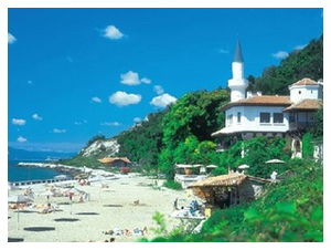
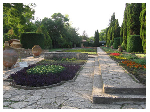
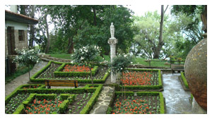
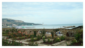
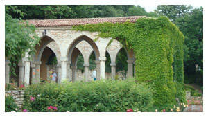
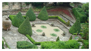
The Palace
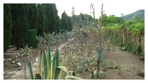
When we speak about Balchik we undoubtedly think about “The Palace” – the formal summer residence of the Romanian queen Maria and the botanical garden.
 Historical museum
Balchik history is displayed chronologically in three halls – from the foundation in the 6th c BC till the middle of the 20th c.
Revival complex
It is a rather interesting sight – includes a church St. Nikola built in 1866 and a revival school from the same period. The complex is now renovated by the project “Beautiful Bulgaria”. This is the most successful historical place after “The Palace”: it is often visited by organized tourists from Albena.
Ethnographical museum
The ethnographic museum is displayed in a beautiful restored house that once belonged to a wealthy local corn – merchant. It shows the cozy atmosphere of typical village and town guest – rooms of the end of the 19 th century.
Art gallery
Is a first Art gallery in South Dobrudza and is situated in a nice building erected in the beginning of 20 century. It exposes modern Bulgarian art and organizes various exhibitions.
Church St. Georgi
The church was built in 1895-1897. Is situated in the center of the town and has one of the most beautiful altars in Dobrudza, the icons are the gifts of the citizens. The church is in a list of protected monuments.
 Church St. Petka
It is situated in the new town. The construction started in 1935 by Romanian authorities, but only in 1954 it was finished and consecrated.
Church St. Elena – Greek church
It is situated in front of the Art gallery and is now used for concerts. Also for summer opera studio
“Teketo” religious cult monument– Obrochoshte village
Built in the 16th century with its original architecture it is unique on the Balkans. The monastery was visited by both Muslims and Christians at the same time.